


la Roque Alric

losjo
User
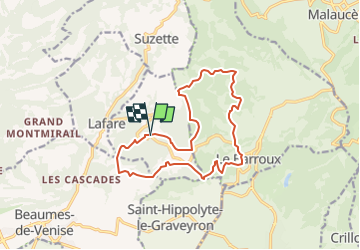

Length
15.2 km

Max alt
511 m

Uphill gradient
650 m
Km-Effort
24 km

Min alt
214 m

Downhill gradient
650 m
Boucle
Yes
Creation date :
2023-01-30 15:35:18.517
Updated on :
2023-01-30 15:38:29.013
5h24
Difficulty : Medium

FREE GPS app for hiking
 SityTrail
IGN / Geographical institutes
SityTrail Plus
The world is yours!
About
Trail On foot of 15.2 km to be discovered at Provence-Alpes-Côte d'Azur, Vaucluse, La Roque-Alric. This trail is proposed by losjo.
Description
rando
Positioning
Country:
France
Region :
Provence-Alpes-Côte d'Azur
Department/Province :
Vaucluse
Municipality :
La Roque-Alric
Location:
Unknown
Start:(Dec)
Start:(UTM)
665285 ; 4889851 (31T) N.
Comments